


esterets

tosan
User

Length
26 km

Max alt
310 m

Uphill gradient
556 m
Km-Effort
33 km

Min alt
85 m

Downhill gradient
557 m
Boucle
Yes
Creation date :
2025-05-08 09:33:39.917
Updated on :
2025-05-08 09:33:43.135
7h30
Difficulty : Very difficult

FREE GPS app for hiking
 SityTrail
IGN / Geographical institutes
SityTrail Plus
The world is yours!
About
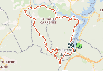
Trail Walking of 26 km to be discovered at Provence-Alpes-Côte d'Azur, Var, Les Adrets-de-l'Estérel. This trail is proposed by tosan.
Positioning
Country:
France
Region :
Provence-Alpes-Côte d'Azur
Department/Province :
Var
Municipality :
Les Adrets-de-l'Estérel
Location:
Unknown
Start:(Dec)
Start:(UTM)
321871 ; 4824462 (32T) N.
Comments